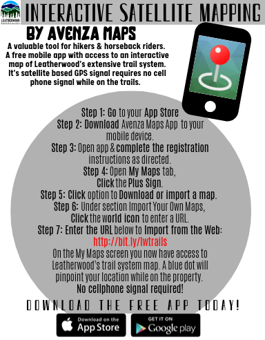
It is with great excitement we are pleased to announce Leatherwood Mountains Resort’s first Interactive Satellite Trail Map! Trail users now have the ability to download an app on your mobile device which allows you to track your location via satellite ANYWHERE on the extensive trail and road system within Leatherwood Mountains. Color coding also helps users identify the different areas they are in such as Joe Town and the Arrowhead sections.
We are incredibly grateful for the hard work of our dear friends Wade and Mary Vann Johnston for seeing this complex project through to its completion. We are certain it is going to be a powerful tool for our trail users for many years to come!
Check it out by following these simple instructions. Download on-site or from home to explore the system (keep in mind your location will not populate as a blue dot until you step foot on the resort)!